
This article is very helpful for electrical engineers working on overhead power line design and any kind of transmission line related business.
Overhead transmission lines play very vital role in our lives because if transmission of energy is not efficient it results power disruptions and losses of power itself.
Below are some of the important considerations which you should keep in mind while doing the routing of electrical transmission line.
The route of a transmission line is decided from the following main considerations.
a) Shortest length, hence least capital cost.
b) Ease during construction and ease in maintenance of the line (route near roads for easy approach & accessibility).
c) Requirement of future loads (sub stations) near the proposed route so that the line can be easily connected.
d) Required separation distance from parallel communication lines (P&T, Railways, etc.) for meeting the conditions of induced voltage for obtaining regulatory approval.
e) Avoiding of forest areas as well as wild life sanctuaries.
f) Cost of securing and clearing right of way (ROW).
g) Maintaining statutory distances from Airports / Helipads.
What to avoid for transmission line routing
The following areas are to be avoided as far as possible while selecting the route of the line.
a) Tough inaccessible areas where approach is difficult.
b) Towns and villages, leaving sufficient margin for their growth.
c) Areas subject to floods, canals or water ways during rainy seasons, tanks, ponds, lakes, etc. and natural hazards.
d) Wooded areas with high trees or fruit bearing trees involving payment of heavy compensations for cutting of the trees.
e) Swamps and shallow lands subject to flood, marshy areas, low lying lands, river beds, and earth slip zones, etc. involving risk to stability to foundations.
f) High hillocks / hilly areas / sand dunes and areas involving abrupt changes in levels and requiring too many long spans.
g) Series of irrigation wells.
h) Rifle shooting areas and other protected areas such as army / defense installations and ammunition depots.
i) Areas which involve risk to human life, damage to public & private properties, religious places, cremation grounds, quarry sites and underground mines, gardens, orchards and plantations.
j) Areas which will create problems of right of way and way leaves.
k) Buildings / Storage areas for explosives or inflammable materials, bulk oil storage tanks, oil or gas pipelines, etc.
Location of overhead power line
The route of the transmission line shall, as far as possible, be the shortest length between the pre – determined sub stations.
The route of the transmission line is to be so located that, as far as possible, it is protected from high winds and falling trees & branches. In hilly tracks, the line is to be routed, as far as
possible, along the side of the hills or through valleys rather than over high points. However, a route of the line very close to steep slopes of hills be avoided as far as possible as there may
be difficulty in obtaining lateral (side) clearance to ground for conductors. Also, there may be overhanging / loose boulders which may roll down and damage the line.
It is desirable to take the line as near the paths and roads as practicable without unduly increasing the length of the line so as to facilitate transportation of material during construction and the patrolling / maintenance of the line. Where the line cannot be routed near paths / roads economically, care shall be taken to see that easy access is possible at every 5 to 8 km. It shall be ensured that all angle / tension points, particularly in the case of 400 kV lines, are approachable to facilitate easy transportation of stringing equipment during construction and for maintenance / breakdowns.
In hilly / mountainous type of terrain or in thickly populated areas, it is generally not advisable to attempt a direct route or try to locate towers in long spans. Small angles of a few degrees cost a little more and add little to the length of the line. Suspension towers (A – type) can be provided for line angles of upto 2 degrees and small angle towers (B – type) can be provided for angles upto 15 degrees.
In general, large angles in the line are to be avoided wherever possible. The magnitude of the angle be small as far as possible and should never be more than 60 degrees.
The line shall be aligned suitably so that it can be diverted / looped in looped out (LILO) to cater for possible future loads / sub stations along the route.
The line route shall be so selected that the voltage induced in parallel running telegraph / telephone / communication / signaling lines / railways does not exceed the prescribed permissible values under fault conditions. The authority approval should be obtained before energizing the line.
The line route shall be at a sufficient distance from the aerodromes / airports so that clearance from the aerodrome / airport authorities is not required or, otherwise, can be obtained easily.
The crossing of Railway tracks shall normally be outside the railway station limits.
Crossing of rivers / canals is preferably done at points where the bed is of the smallest width and the banks on both sides of the rivers / canals are high. The crossing is done at points of the river path where it is unlikely to cut the banks when it is flowing.
The route is selected such that multiple crossings of the same road are avoided. Crossing of roads at very small angles is to be avoided.
When crossing existing higher voltage power lines, the new line shall normally be below such existing lines except in extremely limiting circumstances.
Where crossing existing lower voltage power lines, the new line shall normally be above such existing lines except in circumstances where it is not possible.
When crossing existing power lines of the same voltage, the new line may be above or below such existing lines as per site conditions.
Forest area is to be avoided as far as possible. If forest area cannot be avoided, or if the line route is uneconomical in case forest area is avoided, then the approval of the Forest Department is required.
Reconnaissance Survey of Transmission Line Route
Reconnaissance survey of the transmission line route is to be carried out for deciding upon the most economical line route and the most economical location of towers in view of the high cost per location. The maps covering the complete proposed route of the line shall be obtained. The maps which also cover the topography of the land at an additional distance of 10 km on both sides of the proposed line are also to be obtained. The scale of these maps shall be 1:50,000, i.e., 1 cm. = 500 metres.
These maps are also required for the purpose of obtaining various clearances for the line route. Sufficient number of copies of these maps is to be arranged as per requirement.
These maps give details of the location of villages, towns, cities, ponds, lakes, rivers, canals, roads, orchards, plantations, religious places, hilly area, sand dunes, etc.
After a study of these maps, a tentative transmission line route is selected based on the criteria described above. This is marked on the maps.
A walkover reconnaissance and route alignment survey is first carried out. A vehicle may also be used wherever the terrain permits and where long distances can be seen without obstacles. This is essentially carried out to verify the physical features on the ground which may not be clearly available in the survey maps due to developments that might have taken place subsequent to the preparation of the maps.
The work of reconnaissance survey is essential for the purpose of establishing control points and collection of first hand information of various important field data required for transmission line works.
These are as below:
a) Crossing points of major EHV lines (66 kV and above) & details of the lines.
b) Crossing points of Railway Tracks & details of such points.
c) Crossing points of major rivers & details of such points.
d) Type of terrain and nature of soil strata along the line route.
e) Names of major towns.
f) Important villages or towns coming enroute.
The tentative line route is continuously examined and evaluated with reference to the criteria described above. Changes are proposed / made in the line route wherever required. If necessary, alternative line routes are to be studied / surveyed keeping in view the fundamental considerations for selection of line route.
The best route, modified or alternate, is then provisionally marked on the maps. This route shall form the basis for the detailed survey of the line.
Measurements of Earth Resistivity
Measurements of earth resistivity shall be made at every 2 to 3 km along the tentative route of the transmission line. In case soil characteristics change within 2 to 3 km, the earth resistivity shall also be measured at intermediate locations wherever such characteristics change. The megger reading and soil characteristics shall also be indicated in the earth resistivity results.
Earth resistivity along the route alignment shall be measured in dry weather by the four electrode method keeping inter – electrode spacing of 50 metres.
Test Procedure:
Four electrodes are driven in to the earth at equal intervals s along a straight line in the chosen direction. The depth of the electrodes in the ground shall be of the order of 30 to 50 cm. The earth resistance Megger is placed on a steady and approximately level base and the four electrodes are connected to the instrument terminals as shown in the below figure.
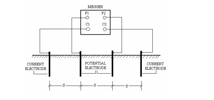
An appropriate range on the instrument, avoiding the two ends of the scale as far as possible, is then selected to obtain clear readings.
The resistivity is calculated from the equation given below:
ρ = 2 π s R
where
ρ = resistivity of soil in ohm – metre,
s = distance between two successive electrodes (50 metres), and
R = Megger reading in ohms.
Sharing is caring:

Discover more from Electrical Engineering 123
Subscribe to get the latest posts sent to your email.